


In the decade city leaders have spent deciding what to do with it, Christchurch's red zone has found its own path. The result is a rare insight into how life moves on after humans have left.

Charlie Mitchell
National Correspondent

Iain McGregor
Visual journalist

Alden Williams
Visual journalist

This strange, sad, lovely landscape is usually called the red zone.
It is nothing like its name. The red zone is vastly, irrepressibly green.
There were 10,000 people living on this land a decade ago, in neighbourhoods that spanned each side of the Avon River, which twists and loops unpredictably across the city. They lived in suburbs with pretty names like Avonside and Bexley and Horseshoe Lake, all of which are now gone, their names erased from the map, stamped instead with the dry, unfeeling "red zone."
It didn't happen all at once; they trickled out over about five years, as they battled insurance claims and the inevitable bureaucracy that comes when your suburb has been told it no longer exists. A small number of people stayed behind to endure the great unknown, and are still there, living their lives in this new landscape.
In 2006, there were more than 10,000 people living along the Avon corridor. By 2013, there were fewer than 1300. Now, there are fewer than 100.


A wetland at Horseshoe Lake. It is merging with parts of the former suburb directly adjacent.
A wetland at Horseshoe Lake. It is merging with parts of the former suburb directly adjacent.
Every house has been torn down, every driveway grassed over, every swimming pool filled. All that remains are the criss-crossing roads, now overgrown and cracked, and the rickety powerline poles starting to sag with the land underneath.
It has left a profound emptiness within the country's second largest city.
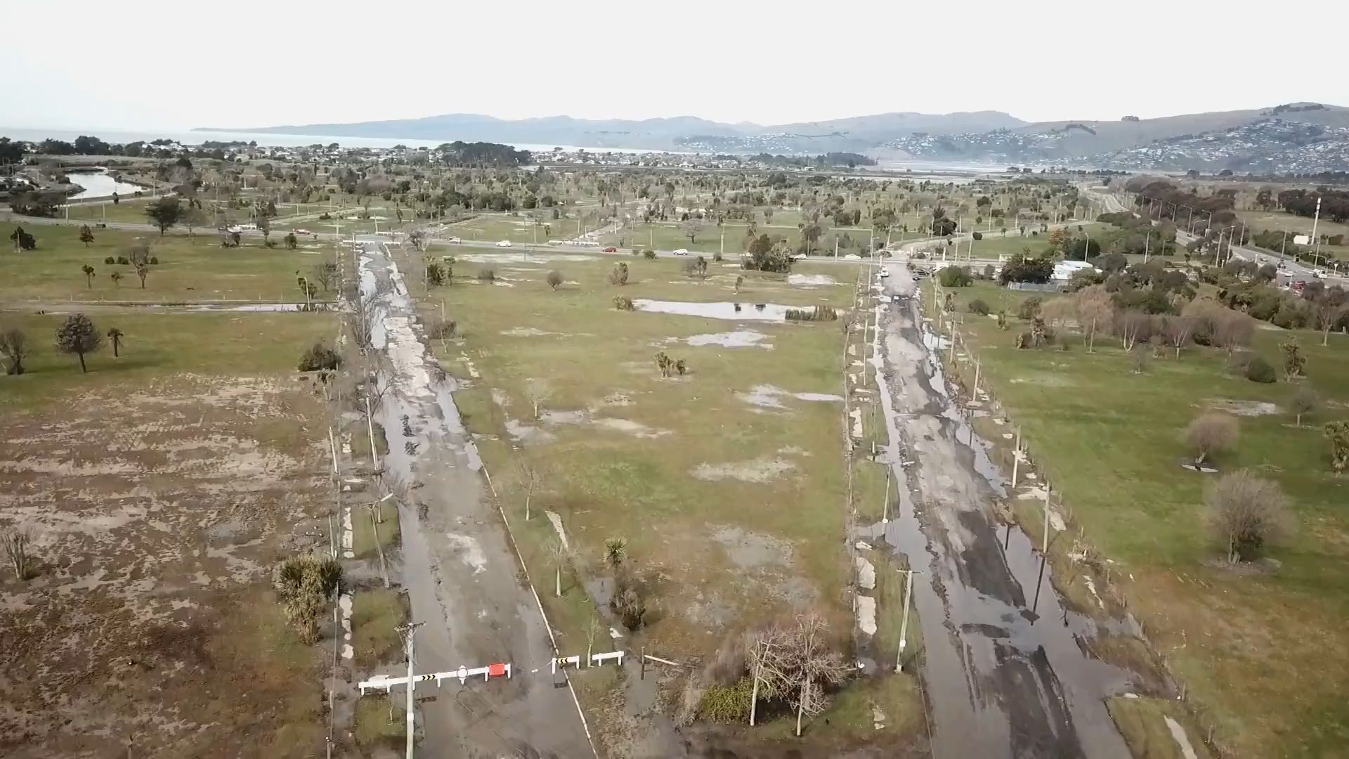
The red zone is nearly twice the size of Manhattan’s Central Park, and four times larger than Hagley Park, which used to be Christchurch's largest public space. An area that large, so full of emotional and physical weight, should be unavoidable and confronting, but it's easy to forget it's there. Roads don't go into the red zone anymore, so you have to seek it out on foot or by bicycle, or catch a glimpse of it from above as you fly in or out of the city, a sprawling green bruise, shocking in its scale.
It’s taken the better part of a decade to answer one simple question: What should be done with this land? In the search for an answer, the red zone has found its own path, in what has been an unusual experiment in how life moves on after humans have left.
BEXLEY IN 2009


BEXLEY IN 2019


The cul-de-sac looks like a human organ. A stomach or a heart, perhaps, slowly succumbing to disease.
Before the earthquakes, it was called Goodman Street. There were a dozen houses lining the head of the cul-de-sac, which backs onto wetlands in Horseshoe Lake, a quiet community dotted with trees, looped by the long, narrow lake for which it was named.
The suburb was sometimes likened to Fendalton, the swankiest part of town, but with more affordable real estate. Before it was a suburb, Horseshoe Lake was a market garden. Before it was a market garden, it was a settlement named Te Oranga. Before then, for eons, as long as the landscape has existed in any recognisable form, it was a wetland.
Today, the Queen owns the swamp formerly known as Goodman Street. She owns a lot of swamps in Christchurch; they're popping up year after year in the red zone, reclaiming the ruins of suburbia owned by the Crown.
Goodman St illustrates what happens when you tame a landscape, then let it roam free again. It is tentatively reverting to its natural state, while still burdened with the shackles of its recent past.
The distinctively wide cul-de-sac, sinking into the mud, is now permanently underwater; green, brackish plant-life is colonising its edges, and the gardens of its former residents, angled straight like arrows, remain untouched.


The cul-de-sac at Goodman St, a decade apart.
The cul-de-sac at Goodman St, a decade apart.
Kenneth and Elizabeth Free, longtime residents of Goodman St, were watching Emmerdale when this landscape transformation began.
It was 12.51pm on February 22, 2011, and an earthquake was barreling its way beneath the city.
Their house was at the end of the cul-de-sac, on the southern end. It would be inaccessible today, with such deep water at what used to be their driveway.
When the rattling stopped, Kenneth rose from his chair and went to the living room window. The ground was bubbling; liquefaction and effluent were seeping to the surface, and it soon surrounded them.
The Frees, like many others in the city's eastern suburbs, had recently finished cleaning up the mess from the last major earthquake, in September 2010. They had lived in their three bedroom home at 54 Goodman St for three decades, and had no plans to leave.
“We were contemplating being taken to Lamb and Hayward [a funeral home] from there,” Kenneth says.
"We would not have moved had the earthquakes not happened."
The February earthquake marked a deep shift, both above and below the surface. Every subsequent aftershock further unmoored the land from the people who lived there, pushing it closer to what was, and seemingly always wanted, to be.
But they had no choice. They were zoned red, and now, it's easy to see why. Their home is a swamp.
DALLINGTON IN 2009

DALLINGTON IN 2019

The term "red zone" is pleasantly uncomplicated, almost childlike in its simplicity; green is good, orange is in-between, and red, of course, is bad.
The people who lived in houses that were zoned red became known as "red zoners". Then the red zoners were split into subsets; "leavers" and "stayers", and for those who were uninsured at the time of the earthquakes, "outcasts".
It was as though the random chaos of a natural disaster, who it affected and how, became an identity marker.
Those designations still linger for some people who had to leave their homes, knowing they would be its last ever occupants. Several former red zone residents said it wasn't the same as moving house. When your neighbourhood is cleared out, it no longer physically exists, but it feels like it should; like a phantom limb, your body still feels the twinge of what was lost.


Rupert Pl in Dallington.
Rupert Pl in Dallington.
We're in a different part of the red zone, now, about 3km south-east of Horseshoe Lake. It used to be called Bexley, and today, it's in ruins.
It hasn’t rained for more than a week, but large parts of Bexley are underwater. The former suburb backs onto a wetland, and the two have started to merge together. Swampy plants and wandering pukeko have spilled over into fading remnants of suburbia. Ducks swim through what used to be an intersection, the road hidden deep beneath the dazzling algal patterns forming on the stagnant water.
Lianne Dalziel finds the rough location of her former home at 22 Arncliff Street, once a two-storey house on a private back section, now a patch of grass pooling with water, only accessible by climbing a fence that warns, gratuitously, of the flood hazard consuming the land.
Dalziel and her husband had lived in that house for more than a decade when, on September 4, 2010, the earthquake sequence began, turning the ground into a grimy jelly that made the water bubble up and everything else sink.
Several hours later, as the sun rose, it became immediately clear Bexley was in strife. Photos from that day show the gridded streets were underwater; mud was flooding into people's homes, and when the streets dried up, the silt was left behind, encasing the asphalt like a tomb.
Today, there are few landmarks signalling what used to be Dalziel's home. Bexley is a monoculture; green, sodden, murky.
“It’s really hard to remember, isn’t it,” Dalziel says.
"In some respects, you can see the landscape is returning to its natural condition... You can see the wetlands almost reclaiming its rightful space."


The long, straight roads of Bexley.
The long, straight roads of Bexley.
The faint remains of a driveway intersecting with the footpath give it away - her neighbour’s plum tree used to be there, Dalziel says - and after scaling the fence, she stands near what used to be her front door.
Many of the houses in Bexley slumped, but some were cleaved in two, as if they were struck by a subterranean thunderbolt. A newish development named Pacific Park, right on the wetlands, was particularly savaged by the liquefied soil groaning beneath the concrete. The development centred on a street named Wetlands Close. One day, it will sink into the wetlands for which it was named.
Dalziel is now the mayor of Christchurch, but during the fall of Bexley, she was the local MP representing Labour, then in opposition. She became a focal point for those in the eastern suburbs navigating the uncertain times of 2011 and 2012; although she had limited power, not being in government, she was going through the same thing everyone else was, too.
“I was representing the people here while at the same time experiencing what so many others were experiencing,” she says.
I got used to a phrase - there were winners and losers - and I knew all of their stories.
In the chaos that ensued, there was little time for Dalziel to process what had happened to her home. This part of Bexley was among the first communities to be “red zoned”, and Dalziel’s house was among the first to be demolished.
She remembers precisely when it happened. It was September 4, 2012, exactly two years after the first earthquake. By then, she and her husband had moved out, but she had started a tradition of returning to Arncliffe Street every September 4 (which she continues to this day).
At her front gate, she found a demolition sign - unbeknownst to her, they were about to knock down her house.
“I didn’t cry [throughout the earthquakes] but I did cry that day,” she says.
“I walked up the drive, went back to the car, and sat there and cried. Then I braced myself for the rest of the day. That did get to me - it was very powerful, for it to happen on that date.”
In the years immediately following the red zoning, some houses were torn down, while others remained upright but empty, pending insurance payouts. Some neighbourhoods started to look like war zones.
Abandoned houses were tagged and occasionally burned down; weeds grew up through the concrete, as gardens were left to grow unmanaged. The battlefield imagery was literal, at times, when the military used some of the empty houses for training.
Those days are over, now that all the buildings are gone. Instead of war-torn suburbia, the red zone has become primal.
There’s no word, exactly, for what’s happening in the red zone. Depending on your perspective, it could be called either decay or regeneration.


A chair in an old garden near Avonside Drive.
A chair in an old garden near Avonside Drive.


Evan Smith in a regnerating forest in the red zone.
Evan Smith in a regnerating forest in the red zone.
There is little international precedent for a sizable portion of a major city being left to forge its own path. In the areas where it has - think the eerie ghost town of Pripyat, near Chernobyl - the superstructure has remained largely intact. Nature intrudes upon the environment, but remains subservient to the urban structures left behind.
The effect is similar in the red zone, though some of its nooks and crannies have gone further, baring little resemblance to what they once were. They have wound back a primordial clock to a time before humans existed, bringing the roads and the gardens and the leftover fences down into the swamp with them.
“I think it’s trying to transition into what it wants to be,” says Evan Smith, a red zoned resident of Avonside and chair of the Avon-Otakaro Network.
"In the Bexley area, you can see wetlands developing already. The only thing stopping it from happening at a much faster rate is the stop banks."
The red zone has, at times, been referred to as a living laboratory. It is an experiment happening in real time; some of it has been intensively managed, the grass mowed and weeds sprayed; other parts have been left alone, to fulfill the will of nature.

Waygreen Ave was a little street. It was whimsical by design; the asphalt was dotted with sections of folksy pink brick, and old English-style lamps adorned the footpaths on each side of the street.
It swung into a gentle bend at its northern end, like a loop in a meandering river.
That's what Waygreen Ave looks like, today: A river. It is permanently underwater, sometimes more than waist-deep. It is home to several families of pukeko, and attracts Canada geese, which have colonised the entire red zone in huge numbers. The road itself has collapsed completely into dirt; the only indication it was once a street are the lampposts, still eerily flanking each side, as the water rises around them.
It is a remarkable transformation because it has happened so quickly. A few years ago, after all the houses on Waygreen Ave had been torn down, it retained its shape, even as weeds grew through the cracked asphalt. Now it is unrecognisable.


Waygreen Ave after the February 2011 earthquake.
Waygreen Ave after the February 2011 earthquake.


Waygreen Ave today.
Waygreen Ave today.
If you reach the northern exit of Waygreen Ave, turn right on Atlantis St, and walk 50m east, you'll find a different landscape entirely. The ground is dry, and the carefully sewn grass is growing well after a recent mow. The roads are cracked, but recognisable. Some still retain painted white lines, a rare sight in the red zone.
When it came time to figure out what to do with the red zone, one of the first tasks was to see what was happening below the ground.
The red zone was split into distinct areas, each of which was given a code, denoting its particular characteristics.
Waygreen Avenue is in area 6B. Much of the street dropped by about a metre following the first few earthquakes, putting it within about half a metre of the underlying groundwater. When it rains, there is nowhere for the water to escape, so it just pools on top.
Also within zone 6B is a large area of new wetlands, on what used to be housing. The plants are about head height; it is the type of wild landscape that would have been here 250 years ago.
It is abundantly clear that housing was incompatible with that area. The reason lies beneath the surface, with what technical documents blandly describe as “thin non-liquefying ground surface crust, resulting in the potential for severe liquefaction-induced subsidence”.
If there was a way to venture beneath Waygreen Ave, below the topsoil and into the underworld we rarely think about, you would be ensconced in grey, permanently saturated soil, before quickly finding the aquifer, the deep pool of water beneath the city.
These are called gley soils, and they are particularly vulnerable to earthquakes because when they are shaken, they don't hold their shape. They collapse into a liquid-like substance - hence the term liquefaction.
The liquefaction seen in Christchurch is among the most severe of its kind seen anywhere in the world. The soils, groaning beneath the weight of the built environment, subsided, further subjecting the land to the forces at work beneath it.
That zone 6B took just a few years to revert to its natural state shows how powerfully the land reasserts itself, when the restrictions of human intervention are released.
The temptation to control natural forces, rather than work with them, had been the source of a lot of problems in Christchurch, Evan Smith says. The red zone was a chance to correct that.
It’s because we’ve tried to tame nature so much that we aren’t as resilient to natural hazards as we should be.
“Instead we can assist it, and guide it on its way.”
Nothing much was left behind in the red zone. Anything that could be picked up was physically taken; much of the rest was torn down.
That is, except for the gardens.
The red zone is full of trees, most of which are tidily sorted into straight lines, demarcating boundaries that no longer exist. Some gardens have flourished, transformed into small stands, taking on a life of their own. Others are limply hanging on, without human management. At the onset of Spring, there are rose bushes everywhere, filling the greenery with shades of red and pink; the scent rides the air.
It is a strange sight. The red zone is a bizarre forest, split into thousands of parts, each one assembled by a person who lived there with no knowledge it would one day become part of a greater whole.
Shortly after the red zoning, the gardens were one of the few tangible connections the red zoners had to their homes.
Some would continue to look after their gardens in the years after departing, and some still do.
Glenda Burt, who lived at her home on Queensbury St in Horseshoe Lake for 43 years, stops by her former home about once a month to see how her plants are growing.
The earthquakes made life in Horseshoe Lake untenable. Much of the suburb sunk, and is now below sea-level. The thin crust beneath the soil was particularly prone to liquefaction, and the eastern parts of the suburb are vulnerable to lateral spreading, in which the soils lurch towards the nearest waterway, in this case, the lake itself.
The lake is important to the city. It is a stormwater basin, accepting the water that bounces of the hard, urban surfaces, channeling it into a nearby pump station. The suburb is likely to become an extension of the lake, to sink further as the groundwater rises, layered with detention ponds and constructed wetlands to cleanse the city's mess.
The abandoned streets are eerily beautiful now. On one early afternoon, a Tui is whistling in the trees while locals walk their dog down the long, barren streets.
When the decision to red zone some areas was made, it was, ostensibly, to allow people to move on. It hasn’t happened as cleanly as that; the emotional barrier between the past and the present is blurred, which brings people back to the places they once lived, even though little of what they could recognise remains.
"I was talking with my daughter last night - she also lost her home - and she said 'if you choose to move house, you’re generally going somewhere because you’ve seen somewhere that’s more appealing and you move on, but you can always come back to that community and visit your neighbours' ... but because the whole community is gone, when you go back, obviously, there’s nothing," Burt says.
"Even though you don’t own it, it’s still yours, because it’s where you were and there were a lot of happy memories there."

One of the many uncertainties following the earthquakes was whether the land could ever be lived on again.
Some places - Waygreen Ave and Goodman St, for example - were clearly not salvageable. But it wasn’t so obvious for other areas, which retained their shape.
That lingering possibility of a return - held both by some of the red zone's former residents, as well as it's new owner, the Crown - became a key consideration in how the area was managed.
If you walk through the Avonside Loop today, it has the air of a quiet, semi-rural park. The suburb had been leafy to begin with, and many of those trees remain. It is busy with dog walkers and joggers, being less than 10 minutes from the city centre. It is fully grassed, and well tended to; it could be an extension of Hagley Park.
Once the red zoned houses started coming down, authorities had to decide what to do with the empty land. It became contentious; should it be left alone, allowed to grow wild? Or should it be tidied up, made to look more like a golf course than ruined suburbia?
For much of the red zone, the latter won out. Maintaining all of the existing vegetation would cost tens of millions of dollars a year, the Government estimated, and allowing it to revert to native forest would impede efforts to rebuild on the land, if that became feasible.
So several landscape categories were identified - the dunes, the estuarine edges, the wet areas - and they were managed accordingly.
Much of the red zone was sorted into a category called the grasslands, and sewn with exotic grasses that turned it green. Native trees were kept, as were the taller exotic trees, most of which were in the older suburbs like Avonside, while much of everything else was cleared.
This approach has been divisive, and expensive. The grasslands are regularly mowed, which itself has cost millions of dollars, while prohibiting a more natural regeneration.
This was the outcome that Dr Colin Meurk, an urban ecologist, had feared. Early on, he had mooted leaving some of the damaged buildings behind, allowing wildlife to take over the ruins, while fostering the regrowth of native species; an approach based on minimal human intervention.
Instead, he describes a “scorched Earth” - exotic grasses sprayed and mowed into oblivion.
What has been talked about is greening the red zone, and reforesting as much of the red zone as we are able to do so given the ground conditions, but they actually prevented that from happening.
One of the earliest - and consistently most popular - ideas for the future of the red zone was a “green spine” unfurling along the river, a long stretch of native bush connecting the central city to the sea.
That concept has survived. It is the centrepiece of the recently announced recovery plan, which broadly sets out what can happen to the red zone, while passing its management on to local authorities.
It’s taken most of a decade to reach this point, where there is even a vague plan for the future. It has been in a holding pattern, kept on life support until a decision could be made.
It has left the landscape transformation envisaged now on the back-foot. If a decision had been made to foster native restoration right away, Meurk says, the red zone could be 30 per cent bush by now.
“Had they agreed and adopted the plan [recently] announced eight years ago, say - and we could have, if a different regime was managing it - we could have managed that succession to a desired endpoint,” he says.
“If they’d decided earlier that, well, it’s never going to be remediated to any great extent, so let’s make it green, then we could have saved a hell of a lot of money and resources.”
While the decision to intensively manage parts of the red zone has been contentious, it hasn’t stopped the landscape from becoming a peaceful, quiet retreat.
Aileen Trist is watching two pukeko lurking through what used to be her home.
It’s nice being here. It’s nice that it’s green.
Trist used to live on Bexley’s Velsheda Street, near the wetlands. Unlike the older part of Bexley, where Lianne Dalziel lived, it is mostly dry.
She is one of the red-zoners whose house was not badly damaged. Apart from her garage separating from the house, there was little structural damage. Unlike some of her neighbours, her house remained livable.
While everyone who was red-zoned could have stayed, they had no way of knowing what sort of community they’d be staying in. They were told that services to their homes may be withdrawn, leaving them to live off the grid, alone in an urban wilderness.
Years later, she rues the decision. One of her neighbours, who was uninsured, is one of two stayers in Bexley. The council recently installed new pipes to service their house. If the opportunity came up, Trist and her husband would move back, but it looks unlikely.


Aileen Trist sitting on a bench dedicated to the former residents of Bexley.
Aileen Trist sitting on a bench dedicated to the former residents of Bexley.
Trist moved to Bexley in large part due to the wetlands.
She was its eyes and ears, organising working bees to clean them up, chasing up the council to fix problems when they arose. She was part of the residents’ association that installed a seat along the wetlands commemorating the farmer who worked the area before it became a suburb.
The community as a whole was unusually tight-knit. “I think it was very rare to have such a close commitment for each other,” she says.
“I think that type of thing is hard to do.”
After the red-zoning, Bexley residents scattered to the wind. Many moved out west, to Rolleston or Leeston; some left the country altogether. The community no longer exists in physical form, but it does digitally, in a Facebook group that has waned as people settle into their new lives.
Trist works in nearby New Brighton, so she drives past her old neighbourhood almost every day. She looks over the flooded grasslands and remembers her old life.
Before they left, the residents installed a new bench, with a plaque that reads: “In memory of the community of Bexley, their devotion to both river and wetlands lost in the earthquakes of 2010 - 2011.”
“Because it’s like this now, it’s not so hard,” she says.


For the first time since its former residents left, the red zone has a future.
The regeneration plan approved last month outlines in broad terms what can happen, where. The red zone is likely to become home to walking tracks, nature trails and bike paths, restored wetlands and perhaps an eco-sanctuary. Parts of it will become a "living laboratory", where methods for adapting to climate change can be trialled. The long, empty roads of Bexley may be used to test driverless vehicles. People may even be able to return, in the form of adaptable housing.
Through it all will be the green spine, turning the red zone into the green zone.
While some former residents remain attached to their old homes, others have accepted their new lives.
Kenneth and Elizabeth Free have moved on from their lives at Goodman St, where they expected to live until their deaths.
They are happy in their new home in Broomfield. While looking for a new house, Kenneth developed stomach cancer, causing him to lose more than 50kg. He looks like a different person.
Although they've moved on, they've kept one relic of their lives at Horseshoe Lake. After the September 2010 earthquake, a cat walked through their living room. It stuck around, and it lives with them to this day.
Kenneth says he'll have to be reincarnated to see what happens to his old home, but he hopes they can clean up the river. In the meantime, the Frees are settled.
"We’ve got some nice neighbours here," he says. "We’re quite happy."
Glenda Burt from Horseshoe Lake now lives in Lincoln, a vastly different landscape, albeit one with the obvious appeal of stable ground.
Like other former residents, she maintains an interest in the area's future. She didn't want it to be built on again, she didn't want anyone to have to go through again what she went through.
Burt says she would like to see it become a place that people could once again enjoy, not like it is now.
“It’s kind of sad to see it the way it is because it was such a nice area,” she says.
“It really reinforces the reason that we had to leave.
You hope that the area brings pleasure to people in the years to come… I hope they don’t just fritter the space away.
Aileen Trist would love to have returned to Bexley. Even if she could have gone back, it would not have been the same, she says; you can't recreate the community that was there.
She hopes people will return to Bexley, and draw from it in the same way she did, as one of its last residents.
"It was Bexley that helped really give me a lot of confidence in myself by joining the residents association … I speak my mind now," she says.
“In the end you’ve made a new life, but we still want that land treated with respect. It would be nice for people to enjoy it.
“It’s not just a suburb, it’s got history with it. We had part of this, and we were very lucky to live here.”
Words: Charlie Mitchell
Aditional reporting: Michael Hayward
Visuals: Iain McGregor & Alden Williams
Design: Kathryn George
Editor: John Hartevelt


