ANDREA VANCE
Senior reporter

IAIN McGREGOR
Visuals
Once an untamed natural wilderness, the West Coast is now firmly on the tourist trail.
Natural wonders, like the Punakaiki rocks and blowholes, spectacular glaciers and the vivid, turquoise waters of the Hokitika Gorge are bringing visitors in droves.
But conservationists and outdoor enthusiasts are horrified. New proposals for the Ōpārara Basin, Fox and Franz Glaciers and Aoraki/Mt Cook have led to accusations that the Department of Conservation wants to “pave over paradise.”
Is the aggressive expansion of the tourism industry happening at the expense of conservation and protection of our most cherished landscapes?
Andrea Vance investigates.
CHAPTER ONE:
VALUE OVER VALUES


“Nowhere is solitude sweeter than on the West Coast.”
This poetic description is the opening lines in the Lonely Planet guide to the West Coast.
Its authors go on to point out that the region forms almost nine per cent of the land area of New Zealand, but contains less than one per cent of its population, about 33,000.
Of them, just over 2000 work in tourism, about 12 per cent of the total workforce. A third are employed by accommodation providers.
Tourism is the second biggest economic driver on the coast (behind dairy). And there are ambitious plans for growth.
Around a million visitors pour into the region each year. By 2021, tourism chiefs want to add another 200,000 to that total.
Forecast expenditure by these visitors would soar: from around $522m in 2017 to $598m by the end of this year (an increase of 7.4 per cent). By 2021, it could be as much as $810 million.
On those numbers, the sector would employ 3485 people.
That’s attractive because the West Coast is bucking national unemployment trends.
According to Infometrics, there were just shy of 16,000 filled jobs in the region last year, and growth was a sluggish 0.8 per cent. The national average is three per cent.


Tourists at the Punakaiki pancake rocks.
Tourists at the Punakaiki pancake rocks.
In ASB’s latest quarterly regional economic scoreboard, the coast was ranked 13th equal, with Gisborne, out of 16 areas.
Since 2012, the West Coast has been in the grip of an economic downturn. It has seen the closure of the Cape Foulwind cement works, near Westport, the mothballing of a gold mine close to Reefton and a slump in commodity prices. Over five years, to 2017, the region lost 1500 jobs and GDP fell by 20 per cent, according to Development West Coast figures.
The area achieved no net GDP growth in the year from March 2017.
Coasters believe they are being left behind.
There is a lingering bitterness over the Government’s refusal to allow mining on conservation land and its reluctance to further intensify dairying.
So, those who scratch out a living in the seasonal sector balk at any limitations to its growth. The heavy storms that batter the region - such as the March flood that ripped out the Waiho River bridge, stranding tourists - make it an unpredictable livelihood.
Growing tensions are pitting conservationists and outdoor lovers against the Department of Conservation (DOC) and tourism chiefs over plans to develop treasured West Coast national parks and increase the number passing through them.


The Ōpārara Cave system, a natural beauty of the West Coast, is attracting more and more tourists.
The Ōpārara Cave system, a natural beauty of the West Coast, is attracting more and more tourists.
In particular, draft management plans for Westland Tai Poutini and Aoraki/Mt Cook national parks, have been heavily criticised by conservationists and outdoor advocates.
Last month, the department put the plans on hold at the request of Ngāi Tahu. But officials are charging ahead with other plans to drive more visitors into the region, and to redevelop the magical Ōpārara cave system.


Matt Newton is a former rescue pilot who built up his helicopter business servicing Taranaki’s oil and gas industry.
When the Government ended all new oil and gas exploration, Newton began to search for opportunities elsewhere.
He expanded his family-run Precision Helicopter business into Hokitika, where he’s been taking tourists up to Ivory Lake, at the head of the Waitaha Valley.
A red-roofed, former meteorological hut sits atop polished rock, overlooking a brilliant blue lake.
It’s a treacherous three-day climb to reach - DOC no longer maintains the track - and the challenge makes it the destination of a lifetime for many trampers.

Matt Newton
Newton got a temporary permit for his flights, carried out a three month trial this summer and has applied for a permanent concession. But there’s opposition within the tramping community.
Permolat is a network of volunteers that look after a network of remote high-country huts and bivouacs in central Westland. Their online community ‘Remote Huts’ criticises Newton’s plans.
“This is a further example of the insidious creep of noise and activity into some of our prized remote destinations and wilderness spaces,” they wrote.
“There are not many of them left and DOC appear to have a pathetically passive and I would say irresponsible response in setting boundaries. It's a real challenge and achievement to reach Ivory Lake by foot and its isolation and remote ambience is what makes it unique.”
Newton’s application is now out for public submission.
He agrees that “it is a very rewarding trek in there. But I have flown in an elderly couple, in their eighties, and they found it very rewarding too. I look at both sides.”
He operates using the “Fly Neighbourly” principles established by the Helicopter Association International.
“If someone is already at the lake, we are not going to be landing, not even flying low. We carry on and not even interrupt their day,” Newton says.
“We’ll see them walking up the track, tents or deck chairs outside the hut, a sign of people being there. We try and create flight paths that are not over huts or regular tramping huts, we try and keep out of people’s sight and people’s ear range.
“I’m all about going in with minimal noise and impact and a lot of that is about how you fly the helicopter. You don’t choose a route that flies up the main track, and you don’t fly down low over the guts of the gully. Our take-off and landing area is miles away from any houses.”


It’s apparent Newton loves Ivory Lake, and wants others to appreciate it. “It is the tail end of an old glacier, that once would have been hundreds of feet higher over where the hut is now and flowed 15km into the valley.
“It’s been receding and Ivory Lake is like a little ice block now, down to that last little bit that will be gone forever one day soon.
“In the spring, the fragrance of the wild flowers is phenomenal, you can smell them from 100 ft up.
“It would be nice to make the parks more accessible. But in saying that, we don’t want to turn them into a circus.”
It took two years for Newton’s landlord to get resource consent to operate out of the Hokitika Gorge.
“A lot of people didn’t want it, so it’s not easy. We’ve been running our business for 15 or 16 years working in oil and gas, seismic exploration, but that’s all tapped out now.
“It’s important for the Government to recognise that they are closing doors for people like me.”


It is this clash of values that it is at the heart of much of the opposition to development in the national parks and the wider West Coast. Around 85 per cent of the region is under Department of Conservation management.
The almost 40-year-old National Parks Act, and the 1987 Conservation Act govern management of the parks.
Inherent in them is a priority to preserve “national park values,” says Federated Mountain Club’s vice president Jan Finlayson.
“There are all sorts of small and large problems with the [draft management] plans.
“They are less plans for national parks, and all that national parks stand for, than they are plans for commercial tourism development. And that is sad. And wrong.

Jan Finlayson
“Our national parks are places of immense and tangible value, they are very special, they are very beautiful. More so all the time, I think, as wild nature becomes ever more compromised and ever-rarer.
“On entering the park, we should be able to have a proper, wild peaceful green national park experience, right from the boundary. You should be able to find quiet, solitude, no fences, no commercial intrusions.
“But people are having to go further away from the park boundary now to find that.
“There are large volumes of people, but people in themselves don't make a lot of noise.
“Where we are finding intrusion is from that commercial activity, the noisy, the mechanised things, the commercial things, and they do spoil it for everybody, recreationalists and tourists alike.”


Aoraki Mount Cook
Aoraki Mount Cook
She is particularly exercised by plans to increase the footprint of Mt Cook village, a tourist centre which mainly houses hotels and staff accommodation.
“The legislation is set up to actively foster traditional, New Zealand recreation, which is by nature, modest in its accoutrement.
“It allows our beautiful natural environment to shine, to be the star. We don't want to look at built structures, we want to appreciate its magic and mysteries.
“These sorts of commercial activities should take place outside the national parks. Twizel and Tekapo are very close by, tourists are adequately catered for outside the national park and that is where we would like to see development take place.
“This plan is shifting away from recreation to commercial tourism. We are not debating the best way to proceed with protecting our beautiful national park but rather to what degree its values will be compromised.”

Simon Milne
Simon Milne, who is director of AUT’s Tourism Research Institute, recently completed a visitor strategy for Great Barrier Island. The strategy strives to have minimal impact on the natural environment and the lifestyles of locals.
“Where-ever you establish a park, where-ever you put in rules, regulations and restrictions you are going to run up against some forms of tension,” Milne says. “Those are things we have to try and manage and work with as carefully as possible.”
Milne says it's vital local communities are on board with tourism development, or tensions quickly develop.


The Pororari River, near Punakaiki.
The Pororari River, near Punakaiki.
“You will have people in the region who feel strongly about a particular resource and there will be others who are looking to exploit that resource, and grow tourism within the local community.
“These are jewels in the crown that attract visitors - even when it is a place that is fairly remote or removed - but they are also something that local people will feel strongly attached to.
“If they feel that their ability to enjoy these resources is reduced significantly … that starts to eat away at the willingness of the people to play the role as hosts to these visitors.”
Losing the good will of locals inevitably impacts on the visitors’ experience, he says.
“In this particular part of the country, there are some strong willed people and people that are living in this area for lifestyle reasons … we need to not only understand what the impacts are on the natural environment but to also get a strong feel about how the community feels about that kind of growth in numbers.”
In Reefton, the closure of a gold mine in 2016 was a huge blow, with the loss of more than 50 jobs. But locals are reshaping the former mining town into a tourist destination. At the heart of their plans is a scheme to revive a derelict powerhouse, the first public electricity in the southern hemisphere.


Greg Topp is rebuilding the old hydro power station in Reefton as a tourist attraction.
Greg Topp is rebuilding the old hydro power station in Reefton as a tourist attraction.
Electrician Greg Topp , of the Reefton Powerhouse Trust, says the idea was formed over a quiet beer but has taken 17 years of planning.
He wants it to be an environmentally friendly tourist attraction. “We are going to recreate the buildings on the original sites… we will produce electricity - it has got to be sustainable. At the end of the day, when you finish you don't want to leave a liability.

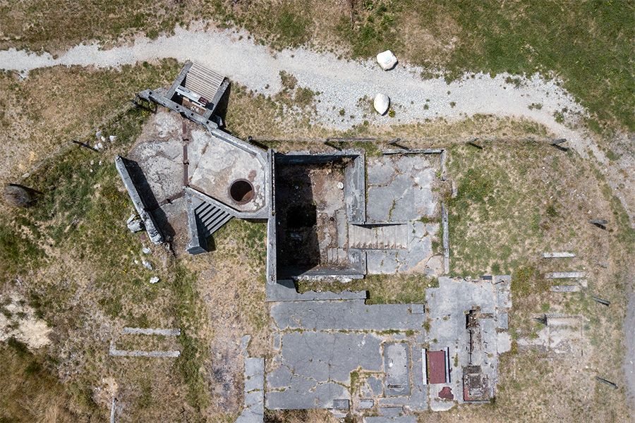
The old Reefton power house foundations will be restored to a tourist attraction.
The old Reefton power house foundations will be restored to a tourist attraction.


The main street in Reefton.
The main street in Reefton.
“I don't believe anyone sets out on the Coast to harm the environment, even our gold and coal miners - and a lot of people will disagree with that - they are really mindful of what they are doing. Coasters are mindful. There is just misconception that we only want to damage things - but no.
“We need to be proud of our heritage, we need to grab hold of it and we need to tell that story,” he says.


Dawson’s Hotel in Reefton.
Dawson’s Hotel in Reefton.
International visitor numbers have swelled - overall the country has seen a 41 per cent increase in five years. More than five million visitors are predicted to arrive in New Zealand by 2024. Local frustrations over traffic, road access, parking, overcrowding, visitor driving, rubbish disposal and freedom camping have already surfaced.
Milne says it partly explains the intense, nation-wide reaction to the “unruly” English tourists, who dominated headlines in January with their anti-social and, sometimes criminal, behaviour.
“We have particular hotspots where we can see the tensions and issues related to over-tourism, especially during high seasons.
“These underlying tensions were that people felt visitors really need to respect the New Zealand environment and the values.”
Jim Little, chief executive of Tourism West Coast, shrugs off the tensions associated with “overtourism.”


Tourists cross the road at the Punakaiki pancake rocks.
Tourists cross the road at the Punakaiki pancake rocks.
“I think that is part of some very, very small areas, or areas of the national parks.
“It's not the parks in general. There are one or two little pressure points where yes, we do need to take some care, I don't think they are not under pressure.”
Asked to identify those problem areas, he says: “Look, I'm not really quite sure.
“I just know there is one or two places where a whole lot of people get into car parks, like the hill where everyone can climb up to take photographs of Wanaka and places like the Tongariro Crossing. Those are some of those examples.
“We get a bit of pressure at the road going up to Franz Josef glacier over February, March but the Department of Conservation manages it very well.”


Finlayson is calling for a “huge mindshift” away from aggressive growth.
“We need a supply-side focus not a demand-side focus. Let’s focus on what our beautiful places, with their immense and tangible values, can provide and what our people and our wonderful recreation tradition can allow - rather than what is being demanded.
“A very good analogy, I think, is one's domestic home. Would we be so prepared to compromise our home values and our home rules and our family life for the demands of absolute strangers? No, we'd be far more likely to lay down the law and tell people on our doorstep how we do things at home and invite them in on condition that they abide by our rules - and respect our way of life and our place.”
CHAPTER TWO:
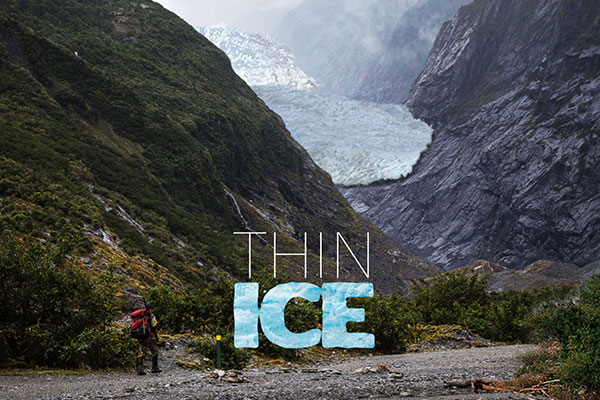
PLANS ON ICE

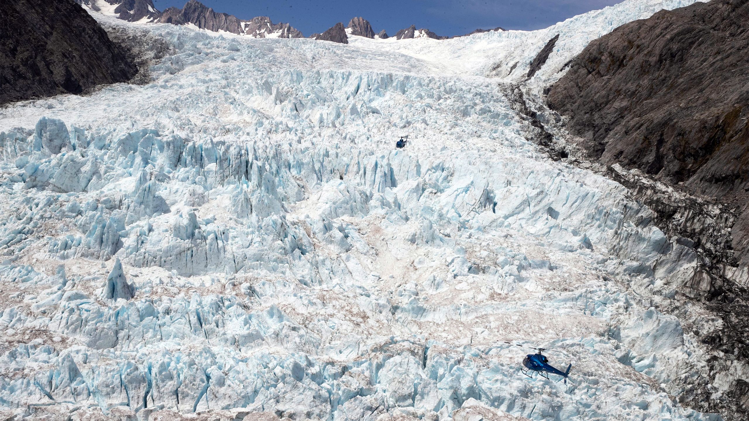
High above the ancient icefalls of Fox and Franz Josef Glaciers, a group of Italian tourists is enjoying an unforgettable experience.
Their helicopter swoops low over the milky Waiho River, before climbing towards the glaciers, hugging the rainforest-clad valley walls.

The visitors peer down into the glacier crevices, before the Glacier Country Helicopters pilot Jay Grift points the bright blue chopper in the direction of Aoraki/Mt Cook.
As it circles around the rugged peak, Lake Pukaki glows turquoise in the distance.
To the right, the Tasman Glacier rises up from its melting snout, frozen in an inexorable flow.
The excited group land on a snow field and are immediately captivated by the frosty air and powdered snow. They snap dozens of photographs, posing with the aircraft and their pilot.
The 45 minute trip is a $495 splurge but a highlight of many New Zealand holidays.


Visitors get the perfect shot after a chopper touches down on a designated landing area near the top of Franz Josef Glacier.
Visitors get the perfect shot after a chopper touches down on a designated landing area near the top of Franz Josef Glacier.
Down on the valley floor, 6km from Fox Glacier, the experience is not so pleasant for local resident Raelene Tuck.
Her home is next to an airfield and she says she’s plagued by the deafening roar of rotor blades, as helicopters take-off and land.
“It’s three helicopters all day long in the peak of the season. It’s up-down, up-down. I’ve got all the windows shut. It does affect my health, the stress, the noise, my ears will ring for a good hour afterwards.”
She’s recorded noise at 90 decibels (the limit is 55). And she’s been writing letters of complaint to the Westland District Council since at least 2006.
Tuck runs Reflections Lodge. Her guests are attracted by the seclusion, a private lake, and panoramic views of Mounts Cook and Tasman. They are often looking for solitude, she says.
“They can’t believe it. They came for the peace and quiet and the views. They arrive and they want to have a rest, but there is no way they can have a rest.”


A tourist chopper is dwarfed by the fantastic scale of the Franz Josef glacier.
A tourist chopper is dwarfed by the fantastic scale of the Franz Josef glacier.
Tuck has sympathy for the helicopter operators: her daughter Poppy is a pilot and runs Glacier Country Helicopters, with her husband Gus Gordon.
Tuck’s not suggesting a limit on numbers - but she’s hoping a proposed new heliport in Fox will ease her problems.
Further up State Highway 6, the stench of aviation fuel hangs over Franz Josef. The beat of chopper blades is incessant as they take off and land from 15 helipads on a grass airfield, just a few hundred yards from the town’s main strip of bars, cafés and souvenir shops.
It’s a source of tension among locals who rely on the trade for their livelihoods, and those who are fed-up with the noise pollution.


Gus Gordon from Glacier Country Helicopters.
Gus Gordon from Glacier Country Helicopters.
And more recently, the Department of Conservation’s proposed draft management plans for Westland Tai Poutini and Aoraki/Mt Cook national parks have made some of both township’s 700-800 permanent residents even more uneasy.
Currently, aircraft landings in the parks are limited. The new plans propose ditching that practice for larger landing zones. That would allow for 73,000 landings in Aoraki/Mt Cook park alone, critics say.
Climbers and trampers also object to landings in the neves of the glaciers and in altitude around revered climbing spots in the Spencer, Balfour and La Perouse, where no landings are currently permitted.

The inclusion of increased activity comes after DOC was ordered to call a halt to a trial which allowed for up to 70 glacier landings a day on Fiordland’s remote Ngapunatoru Plateau.
Opponents argued it breached the national park’s management plan - and the Office of the Ombudsman agreed, ordering it stop in April last year.
Gus Gordon employs 12 people and flies four helicopters out of the back yard of his family home, ten minutes drive from Franz Josef. His is one of eight companies offering tourist flights in the area.
“Some days, we will do ten flights with three machines - so up to 30 landings a day,” he says.


“Some of the bigger companies have got up to 10-16 helicopters. There would 200-300 people directly employed, it is massive.
“We are a town of helicopters and aeroplanes and that is what brings the people to town.”
The chopper companies try to work together to limit noise and air traffic, Gordon says.
“We go up one of the main valleys, the Fox or the Franz, and then we exit the park … we actually land outside the park.
“Then, we come back down - not the Fox or the Franz - which keeps the traffic one-way and really helps with the noise.”
That system also keeps pilots safe.
Gordon says opening the park up to more landings would actually reduce sound.
“We could then move more traffic to one-way and have some good circuits where we go up the valleys and out other valleys that don't have all the trampers and other people. [That way] We can keep noise to a decent level.”


Tasman Glacier
Tasman Glacier
Climate change has seen the glaciers retreat further into the valleys, and they are harder to reach for those who wish to go on foot.
In early March, a massive land slip wiped out the only access road up to Fox Glacier, and its future remains uncertain. Later that month, the worst storm in 37 years battered the coast, leaving a trail of destruction and cutting off the West Coast circuit through the alpine passes.
Gordon says these factors will only increase demand for scenic flights.
“The best way to see [the glaciers] is by helicopter, or by aeroplane.


Fox Glacier
Fox Glacier
“You can look at it from a distance, but getting visitors up there, on the snow, on the outskirts of the glaciers is what really gets them happy. Soon the only way they are going to get there is by helicopter.
“I suppose everyone has got their own opinion and are welcome to it.
“But thousands of guests from all around the world, get to come and stand … on the snow fields and look at Mt Cook, Fox, Franz.
“And I think that's pretty unfair of some other people to say: ‘we will try and limit that.’ It should be shared for everyone.”


There may be another way to take in the incredible panoramic views - but it is at least five years away.
DOC’s plan introduces an amenities area, that could open the door for a gondola over the Franz Josef glacier.
Starting at the existing car park, the 5.7km cableway would cross over the rushing Waiho River, and run parallel to the glistening ice, before ending at a viewing platform close to the Almer glacier.
Skyline Enterprises, the company behind Queenstown’s famous gondola, has been working on the idea since 2012, when a collapse of the ice face made walking in perilous.


Looking towards Queenstown and Lake Wakitipu from the Skyline gondola.
Looking towards Queenstown and Lake Wakitipu from the Skyline gondola.
The gondola plan has been met with horror by outdoor purists.
Forest and Bird's Canterbury-West Coast manager Nicky Snoyink says the installation “risks ecological integrity.”
“It is, essentially, disturbing acres of the front of the valley. This is a really fantastic habitat for kea and rock wren and all kinds of wonderful alpine shrub.
“Building a gondola in that area would require a heap of concrete and the loss of that habitat, a couple of years of disturbance while they are constructing it.”

Nicky Snoyink
But chairman Mark Quickfall rejects the criticism. “I don’t think the impact is as great as what’s perhaps being suggested.
“It is a trade-off. The negative impacts in some people's minds will be the visual impact, a blot on the wilderness landscape, other people won't even give that a thought and see it as another mode of transport.
“Here it is a very wide landscape and we would like to think that the landscape will dwarf the impact of the gondola. We wouldn't want to put something in Franz that is flashing lights, glitzy, bright colours - it will be sympathetic to the environment. It needs to blend in.”


A designated landing area on the top of Franz Josef Glacier.
A designated landing area on the top of Franz Josef Glacier.
He says tourism operators are now much more conscious of mitigating environmental impact.
“It will be very similar to many other examples around the world … where they take people to places they otherwise couldn't have reached.
“We also operate helicopters at both Fox and Franz Josef and frequently you can't operate because of the weather.
“A lot of people leave disappointed because they have come specifically to see the glaciers and they can't get near them.”
Locals have mixed views. Barnabas Young, who’s lived in the town for five years, told DOC in a written submission, that a gondola would “keep the local economy afloat.”
“Normally I see the benefit of keeping these places in their natural state and would say no, but I believe in this unique situation, where we have an amazing natural resource that is retreating at an alarming rate that the more people that can access it easily and safely and in all weather conditions, the better.”
Bronwyn Burrows, of Glacier Country Kayaks believes the gondola “future proofs” the town, which has around 300 permanent residents.
“Due to the retreat of the glacier, the view can no longer be enjoyed from a ‘short walk’ … A gondola will allow less able walkers, and small children to continue to experience the beauty of the Franz Josef Glacier.
“Tourism has been the leading driver of this region since the 1900s and I think that needs to continue. We now have competition for glacier trips in the Mt. Cook region so we need to think outside the box.
“A gondola is a great start to this vision.”


The shimmering blue Lake Pukaki lies on the doorstep of Aoraki/Mount Cook National Park.
The shimmering blue Lake Pukaki lies on the doorstep of Aoraki/Mount Cook National Park.
Other contentious ideas in the plan include allowing recreational dog walking at four tracks: the Tatare Tunnels, Callery Gorge Walk, Canavan's Knob Walk and the Neils Creek Track.
Hang gliders are angry at plans to put restrictions around the glaciers, and fishers and hunters don’t like a proposed ban on personal motorised boating in some areas.
There is also alarm at a lack of focus on climate change mitigation.
Westland Tai Poutini and Aoraki/Mt Cook National Parks sit astride the Main Divide and stretch from our highest mountain peaks right down to the rugged, driftwood-strewn, beaches of Westland.
Along with Mount Aspiring and Fiordland national parks, they form part of Te Wahipounamu (The Place of Greenstone) South Westland, a 2.6 million hectare UNESCO World Heritage site. And they are a sanctuary for threatened native species, like kiwi, jewelled gecko and white heron.
Both draft management plans set down the guidelines for how the parks and their epic landscapes, waterways, protected species and all human activity will be managed for the coming decade.
Their untouched beauty holds a special place in Kiwi hearts, reflected in the storm of controversy over the plans.
DOC received 1361 submissions on the Westland Tai Poutini plan, and 889 for Aoraki/Mt Cook.
The consultation process closed in early February. On the same day, DOC announced it had pressed pause on both drafts, at the request of Ngāi Tahu.
That came after a landmark Supreme Court ruling in favour of Auckland’s Ngāi Tai hapū, who had argued the Crown breached Treaty of Waitangi principles by granting tourism concessions on the Gulf islands of Motutapu and Rangitoto.
Ngāi Tai’s lawyers argued as mana whenua they should have exclusive tourism rights on their ancestral land, and a right to veto commercial operations.
DOC had granted concessions for guided walks and tractor/ trailer tours, which breached section 4 of the Conservation Act.
That’s a “powerful” clause which can require DOC to give effect to the principles of the Treaty. It should enable iwi to reconnect to their ancestral lands by taking up opportunities on the conservation estate. And it can require them to decline concessions by other operators.
DOC and the iwi say they now need time to work out what this means for the national park plans.
DOC’s Director of Planning, Permissions and Land Marie Long responded to Stuff’s questions with a written statement.
She said: “DOC will not be commenting on individual submissions on the draft Taipoutini Westland and Aoraki/Mt Cook National Park Management Plans. We have paused the review of the plans while we work through the implications of the Supreme Court’s decision relating to Ngāi Tai ki Tamaki and what that might mean for Ngāi Tahu.
“We are aware that people have raised concerns about several issues such as noise and strategies for dealing with increased visitor numbers and we will be looking at ways of engaging with people about the content of the submissions.
“Once consultations with Ngāi Tahu have progressed we will come back and talk to people about their concerns.”
Ngāi Tahu refused to speak to Stuff for this article.
CHAPTER THREE:
PAVE OVER PARADISE


It’s a rough old road to the Ōpārara Basin.
Narrow twists and turns make the 15 km trip up Mccallums Mill Rd a slow, but picturesque, one.


The road into the Ōpārara Basin basin has had a number of accidents and development is planned to improve it.
The road into the Ōpārara Basin basin has had a number of accidents and development is planned to improve it.
Native forest drips over the gravel forestry track, as it traces its way into the heart of the Kahurangi National Park.
The busy car park is your first introduction to this spectacular wonderland. Blue duck (whio) keep watch over their nests around its edges.
From there, a short, gentle path under a beech canopy runs alongside a whiskey-hued river.


The Ōpārara River.
The Ōpārara River.
Over centuries those waters slowly dissolved limestone rock, leaving behind the 43 metre-high, 79 metre-long Ōpārara Arch, at the end of the track.
It never happened, but locals love to tell gullible tourists how an aeroplane once cleared the span, the largest limestone arch in Australasia.
A longer walk, through rimu and towering kahikatea and over a forest floor carpeted with moss and ferns passes by the Moria Gate Arch. It's named after the abandoned, underground dwarf kingdom of the Lord of the Rings and The Hobbit.
Duck down a side-track, grasping a chain and railings over slippery rocks and step into a dark and ancient Tolkien-like world. The chamber is 19 metres high, and overhead dripstones jut from the rocky ceiling. Underneath, whio paddle through the slow-moving water.


Neil Silverwood on the walkway at the Ōpārara Basin arch.
Neil Silverwood on the walkway at the Ōpārara Basin arch.
A path back to the car park, over the arch, leads to the Mirror Tarn where placid, clear waters reflect back the surrounding primaeval forest and mountainscapes.
The maze of tracks is already a popular destination. The gentle walks make it an easy visit for families to spend the day picnic-ing and wandering in the accessible caves.
"What makes Ōpārara Basin so special is that it is completely undeveloped," photographer, outdoor guide and caver Neil Silverwood says. He’s been exploring the vast network for thirty years.
“It’s probably the best place people can go to see limestone arches and caves in a fully preserved state, free of intrusive structures.
"If this was anywhere else in the world, we would have suspended walkways going through the arch, we'd probably have a lift coming right into the cave entrance.
“The Ōpārara caves are not unique - caves in the North Island are similar but those places have all been tamed. They have artificial walkways, stair wells going down inside, lights. You can raft or abseil through, they are heavily modified, the surface has been farmed.
"You can go to Waitomo and do that, but if you want to go to a place which is completely natural you come to the Ōpārara. It is completely untouched. It is wild.”
An estimated 12-15,000 now come to experience that wilderness every year. But that's not enough for tourism bosses, who have developed a strategy to boost numbers touring the West Coast by a quarter.


Tourists in the Ōpārara Basin arches.
Tourists in the Ōpārara Basin arches.
They want to draw crowds north to the Buller region, away from choke points at Punakaiki and Franz Josef.
A Tourism West Coast marketing plan, produced in 2017, aspires to boosting Ōpārara visitors to 66,837 by 2021.
Numbers passing through the Basin have already begun to increase organically. Records only go back a decade but visitors have tripled in that time.
At the peak of the 2016/17 summer season just over 11,250 made the trip, two hours north of Westport.
To bring more people in, Tourism West Coast want to transform the caves into a "world class visitor attraction."
In November, the Government’s Provincial Growth Fund contributed $5.6m to the development, a share of an almost $90m investment in the West Coast’s tourist infrastructure.

Tourism growth has boomed in Westland, home to the glaciers, but visitor expenditure has declined in Buller.
It’s a region already buffeted by fluctuating dairy and coal prices and it was the area most affected by the West Coast’s economic downturn. Between 2012and 2018, 1452 jobs were lost in Buller, and its GDP decreased by 44 per cent.
The only sector to show GDP growth is tourism - which grew by just over 22 per cent, although Development West Coast points out that growth came from a low base.
The pay-off in luring tourists north to Karamea, could be an extra 155 jobs to the area - a 63 per cent increase. But at what cost?


The Ōpārara Basin from above.
The Ōpārara Basin from above.
For around 35 million years, Ōpārara lay untouched. Its only visitors were forest creatures and flightless birds, which fell through the shafts to their deaths. Fossilised bones now litter the rock floors.
In the late 1880s, gold miners jotted the underground cave system on their maps. But up until the 1970s, the caves were mainly isolated.
Forest Service workers stumbled over a cave entrance while logging native timber. Within a few years caving enthusiasts began to explore the dark, cool depths.
Scientists followed. The Honeycomb Hill cave system was discovered. Inside was a treasure trove of relics of creatures dead for more than 20,000 years, including ancient snails, nine types of moa and the Haast eagle.
It was declared a Specially Protected Area. Public access to the most scientifically important areas was restricted, and you can only visit with a specially trained guide.


Neil Silverwood at the entry to the Ōpārara Basin arches.
Neil Silverwood at the entry to the Ōpārara Basin arches.
Development of the wider area into a tourist attraction continued apace.
More than 30km of paths and mountain biking tracks were created and opened by celebrity botanist David Bellamy in 2008.
Outdoor enthusiasts were lured into a side-trip from the nearby Heaphy Great Walk.
The new visitors have put the cave system under pressure.
Ōpārara is a karst terrain, canyons and caves hewn out of rock over millions of years. New Zealand has very little karst (just three per cent of the landscape, compared with a global average of 14 per cent) and humans have already destroyed or transformed two-thirds of it through industry, agriculture and tourism.
Delicate limestone crumbles at the slightest touch, and formations sculpted over millions of years can be carelessly destroyed in a heartbeat.
The Honeycomb system is also reaching the end of its long "life." The limestone layers sit on top of granite, which can't be carved away like the more dissolvable limestone.
"It is probably the last area left where tourists can see unmodified karst landscapes, still in its original form," Silverwood, a member of the New Zealand Speleological Society, which represents cavers, explains.
"That is what the drawcard for the Ōpārara is, and that is why we have got to preserve it exactly as it is now."

Conservationists reserve their deepest concern for Ōpārara's shy and rare wildlife. The Nelson cave spider, or spelungula cavernicola, has made the twilight caverns its home.
“It is New Zealand's largest spider. It is terrifying actually. It is about the size of your hand, and there are very few … [they] live in the Ōpārara Basin in a handful of caves, the Heaphy River and a couple in Golden Bay,” Silverwood says.
The huge, furry beasties are disturbed by curious tourists brandishing torches or camera flashes, and are being driven further and further into the cave system.
They find their prey, mostly weta, by vibration so heavy footfall can be disconcerting. Their egg sacs, which hang down from the cave roofs, are extremely fragile.
At the moment, the spiders live in the Crazy Paving and Box Canyon caves, where access is unrestricted.
Spider-lovers say that might need to change. Their conservation status is "at risk" and they are the only spider protected under the Wildlife Act.
“On a recent trip, I saw tourists actually going around the cave searching for spelungula so they could get a selfie taken with them,” Silverwood says.
“We also saw a crushed egg sac. It had been knocked off the roof by someone's helmet and fallen down, still with the baby spelungula spiders [inside], and someone had actually stepped on it and crushed it.
"It's having a negative effect on the spelungula...when I first came here you could walk into Box or Crazy Paving and just see loads of spiders, now there is a last few … it looks like that population could be crashing. If we lose the population in this cave it's a massive blow for the spelungula.”


New Zealand's largest and rarest spider spelungula cavernicola can be found in the Ōpārara Basin.
New Zealand's largest and rarest spider spelungula cavernicola can be found in the Ōpārara Basin.
Increased human activity also puts the Basin's other rich flora and fauna at risk. It’s meat-eating, giant land snail are endangered, as are whio, New Zealand falcon and kākā.
The Department of Conservation (DOC) is yet to carry out an environmental assessment on the potential impacts of increased visitor numbers.
Silverwood says that's unusual because it is usually a first step in developing natural wonders. He believes it sets an uncomfortable precedent in which business interests are taking the lead.
"The Department of Conservation is working closely with MBIE [the Ministry of Business, Innovation and Employment] and Tourism West Coast to develop this Basin," he says.
"We've never seen DOC take on a development type role before. It's role is to look after our biodiversity, manage recreation and allow for tourism.
“But we are now seeing the department focus, more now than ever, on tourism rather than on recreation and biodiversity."


Neil Silverwood at the Ōpārara Basin, where development work is planned.
Neil Silverwood at the Ōpārara Basin, where development work is planned.
Forest and Bird's Canterbury-West Coast manager Nicky Snoyink shares Silverwood’s worries.
“The bottom line is, these caves, especially the Honeycomb caves, are specially protected.
“They are a living or a natural heritage and the protection for them is already inadequate.”
Currently, the Ōpārara Valley Project Trust operates guided tours into the Honeycomb Hill Caves, with a concession from DOC. Numbers are strictly limited and the tours cost between $95 and $150.
Snoyink says that doesn’t keep unwelcome visitors - or looters - out. There is a thriving market for illegally plundered moa remains, which fetch up to $350 for a single bone.
“There is a gate you can get around to wander on in. Subsequently, the moa bones, get pilfered and the next thing is they are for sale.
“[The concession] also doesn't stop the free, independent travellers, they can walk in there morning, noon and night.
“It is impossible to fence it, or gate it off because there are heaps of different entrances. But putting a gate close to the existing car park would make it a 5km walk and that would put people off. That's probably a really good start.”
Conservationists are relieved elaborate plans to create a Moa-themed attraction at the caves were wound back last year. Karamea was to be rebranded “Moa Town,” with a giant bird installation planned and marketing based around a “lost world” of extinct moa and Haast eagles.


Neil Silverwood looking through the narrows of the Ōpārara Basin caves.
Neil Silverwood looking through the narrows of the Ōpārara Basin caves.
But the discordant proposals have left them mistrustful of further development.
“Originally, it was a Disney-esque type development, with artificial lights and suspended walkways, blasting open cave entrances to make them more accessible, blasting open a spring to make it more visually appealing, so a really aggressive development,” Silverwood says.
“It is still not to the point where I am happy with it. They are still planning a number of intrusive structures and actually it is not allowed for, if you look at the legislation which the Department of Conservation has to use when they manage the park, it doesn't allow for any intrusive structures in the Ōpārara Basin.
“It is really heartbreaking to see the degradation of the Ōpārara Basin - we have got to protect these places.”
Tourism West Coast chief executive Jim Little admits the Moa theme park plans were “outlandish.”
“Somebody from Lincoln University came up with some sort of what we would call outlandish ideas. Just as a concept of some things we could be considering. It was never really taken seriously anyway. Those things got pushed to one side.”
He says the new plan is an infrastructure upgrade and “all about retaining the natural heritage of the place.”
Most of the $5.7m cash injection will go into widening the road, which currently isn’t suitable for motorhomes. Little says there will also be new toilets, hand rails and pathways.
And a viewing platform is planned for the Mirror Tarn.
He’s vague on the details, and refers queries to DOC. His visitor number projections are also much more conservative than the 60,000 outlined in his agency’s strategy documents.
“If they could get it up to around about 25,000 that would be the maximum during the year. That's sustainable, it works for the small community of Karamea.”
Little says he’s not worried larger crowds will put pressure on the ecosystem.
“Basically if people stick to the tracks and walkways and so on, there is no change to that. If it is properly managed, no, I'm not [concerned]. The Department of Conservation and others need to manage it properly and do a good job of it.”
DOC’s Buller Operations Manager Robert Dickson says plans are still at a “concept phase” and the agency has been consulting with the community, conservation boards, Forest and Bird, Federated Mountain Club and the New Zealand Speleological Society.
“DOC will be managing the work and it will be in line with infrastructure at other DOC sites – low key, understated and designed to protect the environment with the increasing number of visitors the site receives,” he says.


The Ōpārara Basin arch.
The Ōpārara Basin arch.
No boardwalks or platforms are planned for inside the caves, Dickson says. “A plan to place a viewing area at the Mirror Tarn, to alleviate the effects of people walking inappropriately around it will require further scoping and an assessment of environmental effects.”
Visitor numbers to the site will be monitored over coming summers and the assessment will be done before any work is carried out , he says. “DOC is mindful of increasing numbers of visitors.
“With the increase in visitors comes additional risk to the wildlife within those caves. The Nelson Cave Spider is one example of this. Both caves will be part of an environmental assessment carried out by a cave fauna specialist to provide guidance and advice on how to ensure the best outcomes for cave dwelling species – this could include limiting access to these caves.”
Dickson says there are 65 entrances to the Honeycomb Hill Cave system.
“Gating these is not feasible. Additional security by way of camera monitoring will be installed at the carpark and cave access points which will remotely trigger alerts to rangers should people other than the concession holder be detected.”
Words: Andrea Vance
Visuals: Iain McGregor
Design & layout: Aaron Wood
Editor: John Hartevelt